NORTHERN NAVIGATORS
Invite you a local event at
Shaftoe Crags
Sunday, 16th February 2020
F I N A L D E T A I L S
| WARNING | There is some severe weather forecast for the next few days, but the farmer is happy about the use of the parking area. Following an inspection today the field was wet but still firm and should be OK for cars but not heavier vehicles such as campervans and motorhomes. |
| Travel : | The event will be signed from a junction on the Belsay to Scots Gap road at grid reference NZ070824. About 1km to the west of Bolam Lake, turn left at Bolam West Houses. |
| Please drive carefully through the houses - this is a rough narrow lane with many potholes. | |
| Parking : | Parking is on a firm field at grid ref NZ063822. When wet it is not really suitable for campervans, motorhomes and heavier vehicles. |
| Registration : | from 10.00 - 12.00, with starts from 10.30 - 12.30 |
| Lone competitors should leave their details with registration. | |
| Start / finish : | the start will be about 100m from registration - there is an awkward double gate to get through. The finish will be approximately 1km away and will be unmanned - don't forget to punch the finish control. Once finished, follow the orange tapes northwards to a gate in the wall (gate must be left closed), cross the open pasture eastwards to another small gate by the pond at the bottom of the hill, then back to download. |
| All competitors must report to registration / download before they leave the area. | |
| Courses : | Yellow, Orange, Light Green, Short Green, Green, Blue, Brown (see control descriptions for details). |
| The Yellow course will have a short taped route to get them safely to a crossing point. The Brown course will have two back to back maps in a poly bag. | |
| Fees : | Senior (aged 21 and over) - £7
Junior (aged 20 and under) + students - £2 School children (up to age 16) - £1. |
| Pre-entry : | There is NO pre-entry for this event. Entry on the day only - first come first served. |
| EPS : | This event will use the EMIT TFP (Touch-Free Pro) electronic system. The Pro system is more reliable than the older standard training boxes and can be passed faster. E-tags will be available free of charge on the day, but competitors will be charged for any loss (lost or non-returned E-tags will be charged at £55). Unlike previous systems the E-tag is worn much like a wrist watch and needs to be passed within about 10-15cm of the control box. There is a small red LED on the E-tag which flashes for about 10 seconds indicating a successful pass (sorry, no audible signal) - it will be your responsibility to check. There is no clear station for this system as the E-tag is cleared at the start control and stopped at the finish. There will be a sample control near registration for you to see the E-tag in action and instruction in the use of the system will be available on the day. |
| Map : | Shaftoe Crags, Scale 1:10000, contours 5m, A4 size. The map for this event was re-surveyed and re-drawn by Rob McKenna, winter 2019/20, based on a Dave Caudwell map and updated to ISOM2017. The area was last used January 2017. Maps will be printed on waterproof paper. The Brown course will have two maps printed back to back. |
| Control desc : | will be on the front of the map. They will be in written format for Yellow and Orange courses, but pictorial for Light Green to Brown. They can be downloaded here. Click here for a copy of the IOF control descriptions. |
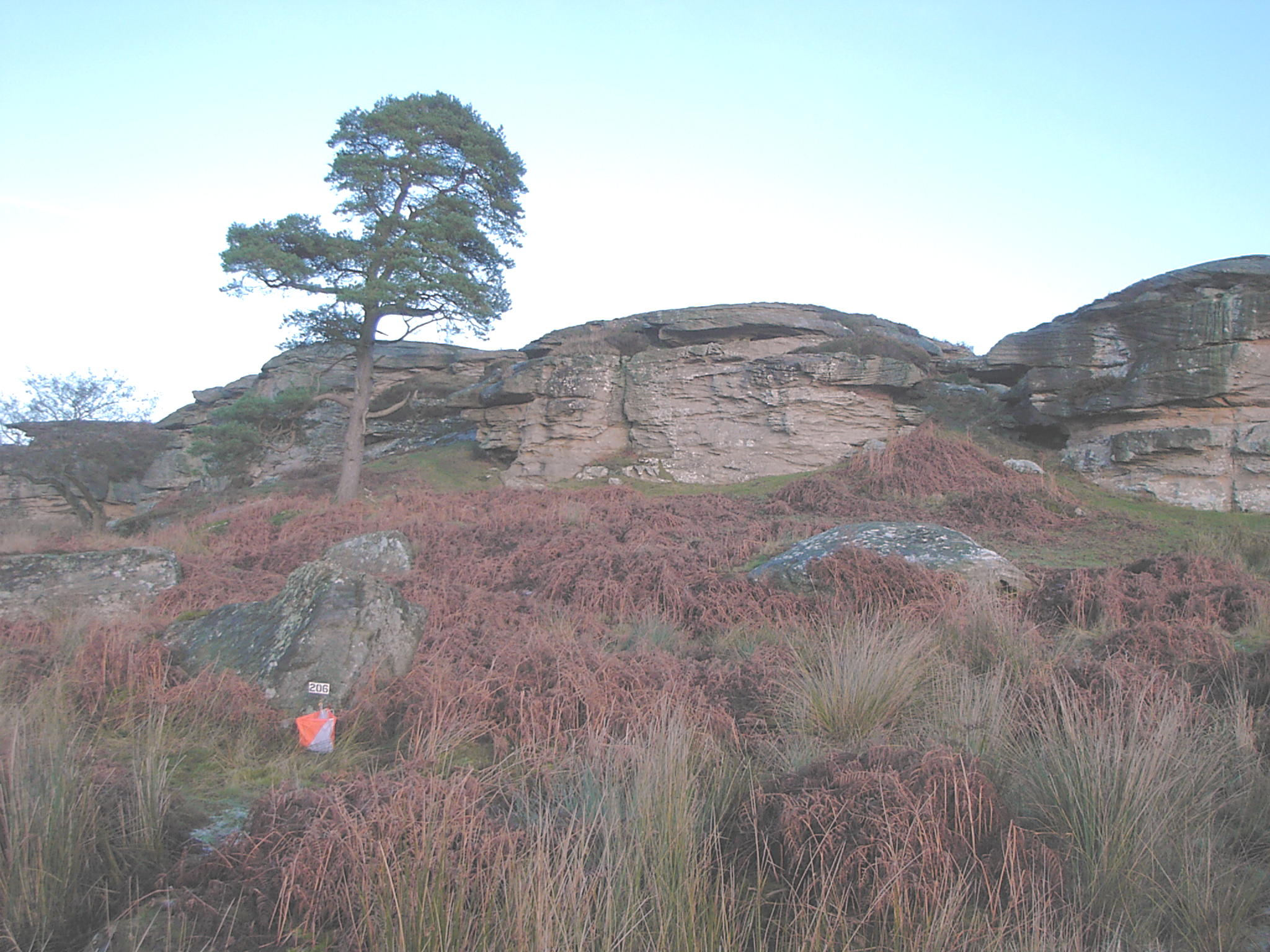
| Terrain : | Fast, runable, open grassy moorland, with some rough pasture, small deciduous woodland and many complex rock features. There are some steep slopes and impressive rock features (see photo) |
| Safety : | Whilst the area only lies about 200m above sea level it can be very exposed if the weather turns nasty. Please come prepared as cagoules may be compulsory. All courses will have at least one crossing point which will be a wooden stile across a ruined wall - please take care when using this. The Brown will also have two small gates which must be left closed after use. |
| Facilities : | Limited toilet, sorry there will be no water at the finish, please bring your own supply. |
| Dogs : | Dogs will NOT be allowed at this event (a stipulation of the landowners) - there may be cattle and sheep grazing in the parking area. There may be limited parking in the lane leading to the area for dog owners. |
| Results : | Individual split times will be available at the download station on the day. Full results will be posted on the NN website - www.northern-navigators.org.uk
If you require a paper copy of the results, please leave your details at registration with 70p to cover postage. |
| Insurance : | Please note that if you have competed in three orienteering events registered with British Orienteering and you have not joined an orienteering club which is a member of British Orienteering then you are not covered by our public liability insurance. This basically means that any damage done by you is your responsibility. |
| Officials : | Organiser - Boris Spence, tel: 01670 860897, email |
| Planner - Rob McKenna | |
| Controller - Julian Warren (NN) | |